My buddies Todd and Ken came out from Washington to fill freezers with Montana’s highly available and affordable whitetail doe B tags. We’d punched a few of those permits before the guys found out that the next day, my last in camp, was also my last day tohunt elkfor the season. They insisted we go into mountains the next morning.
Unfamiliar with the surrounding high country, I sat up late in my teepee that night putting the screws toonX, looking for the perfect arrangement of topographical squiggles. And then there it was; one of the mountains nearest our camp. A steep, open, south-facing slope joining at the ridge with timbered benches on the north side. A few springs appeared in the saddle and a lower bowl. The approach looked awful with no roads or distinct trails on the mountain—which meant it could be loaded with elk in that pressured area.
The approachwasawful. It took us the better part of three hours the next morning to ascend 2,500 vertical feet up the south side. But, less than fifteen minutes into the timber along the bench on the north slope, I had a raghorn bull twitching on the ground.
How Does Topography Work?
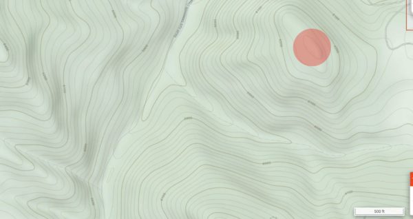
If you look at a map and see a pattern similar to the growth rings in a tree, you’ve got yourself some topography. This differs from relief maps, which show terrain through shading, and aerial imaging, pictures of the ground from planes or satellites. The roughly parallel lines on a topo map each denote a specific elevation above sea level.
They are labeled at intervals, often every 200 feet. This creates concentric rings that paint a picture of the terrain. Because each line corresponds to a specific elevation level, lines close together indicate a steep area, while lines spaced far apart indicate gentle slope or flat ground. Where the rings constrict the furthest, you’ll often see a circle or shape with nothing inside it, indicating a peak or high point.
What Do I Look For?
Elk, like most animals, have three basic requirements: food, shelter, and water. Pure topographic maps don’t help you with all of that. You’ll need a relief or aerial image map, or boots on the ground, to locate protective timber and grassy meadows, although some topo maps do include green overlays where trees exist. Topo maps usually show water courses and sources. But where they really stand above the other map types is detecting slope angle and the particular terrain features that elk key in on.
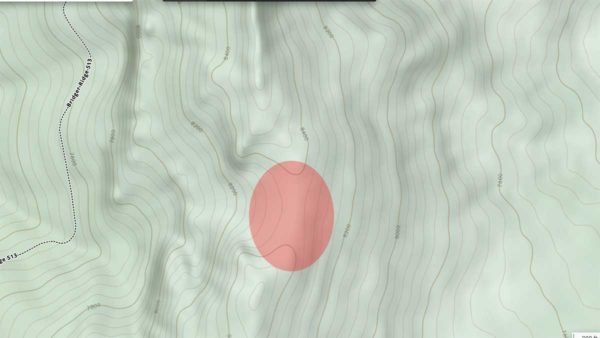
Benches
Anyone who’s spent time hunting elk knows they are comfortable in and often seek out really steep country. However, this is not so much an essential feature of elk ecology as it is with say mountain sheep or goats. They go into the steep, nasty shit to get away from you and me.
But they don’t like just any ol’ steep country. They’re often using the slope angle as security cover to hole up, hide from hunters, and rest after the rut, so they need a comfortable place to lie down. They’re big animals and need a relatively big, flat spot to get cozy—unlike mule deer which can tuck into almost any discernable depression.
This is where topo shines. In the steep country elk often occupy, look for breaks in that steepness, often called benches. These will show up as a lot of lines close together, broken by a few lines spaced further apart. They can be as small as a few hundred square feet to running miles along a mountainside. Benches are one of the most important terrain features to seek out, especially in heavily timbered areas. You could spend weeks still-hunting deep woods and never see anything, only to find that one bench that’s loaded with elk. Target these places in your digital scouting to reduce aimless wandering. All the better if you can find steep country benches with water or food nearby.
The same principle applies to terraces in descending ridgelines. Elk regularly travel ridgelines to or from water and will pick the flatter places in the ridge to feed or bed up. They especially like bedding on ridge terraces because of the olfactory advantages provided. They can sit looking downwind and smelling upwind no matter the stage or the thermals.
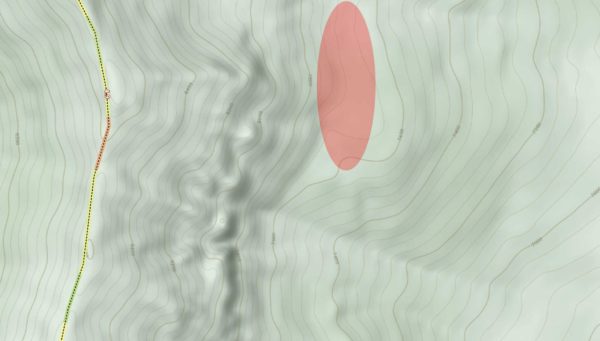
Saddles
To rephrase the previous point, elk are comfortable in steep country, but despite that proclivity they like flat areas more than you might expect. The reasons for this vary by season, but it probably has the most to do with food. Elk are grazers not browsers, meaning they will chow down on the highest quality food they can find, usually at dawn and dusk. Good soil to grow this kind of good quality forage typically occurs on flatter, somewhat low-lying areas. Topsoil erodes off ridgelines and steep faces, but it will collect in bowls and saddles.
A saddle is the low point in a ridge, or the spot where two ridges come together. Picture the seat of a horse-riding saddle. These geographic features are natural transition zones, as elk will generally take the path of least resistance to get from one side of the mountain to the other. This makes saddles great intercept zones, as well as great places to call from in September and October seasons. Elk on either side of the ridge can hear you calling instead of just talking to one side.
There’s just something about prominent saddles and passes between one drainage and another. Elk love them. Grass often grows profusely, water is more likely to be present, and elk have escape routes uphill or downhill in four directions. Saddles can also congregate rutting activity as separate herds come off adjoining mountains.
Saddles are a great first feature to key in on. On your topo map, look for two U-shaped lines with the bottom of the U’s pointing toward each other and some space between. This will usually show up somewhere in between two peaks or points.
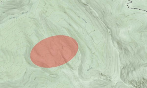
Bowls
The classic-est of classic elk country might be described as a high mountain hanging valley, peaks above, dotted with wallows and patches of timber. It’s what we’re all looking for and often what elk are looking for. These will appear in topo almost like a clamshell pattern: lines fanning out from a flat hinge point, getting closer and closer together as they get further away from the center.
Bowls are regular features of most Western mountain ranges, so you’ll need to get a little more specific. Look for ones that might be better described as a cirque—high and out of reach, not necessarily the terminus for a major valley. These are the kinds of hidey-holes that elk love. These hanging valleys can’t be seen from below, hunters have to work to get there, and there are often springs and good grass present.
Vantage Points
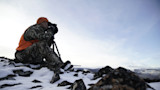
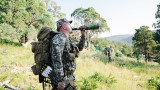
Oftentimes with elk, finding a place from which to locate animals is just as important as finding areas where the animals might be. Look for the highest point you can reasonably reach or a peak or point that stands alone, offering a broad view. If that isn’t feasible (which it often isn’t) then you can first work on locating the elk-holding terrain listed above—then find the opposing mountainside where you can glass into that country. It is often more efficient to sit and look over a lot of good country than to climb way the hell up into one isolated piece of habitat to look for elk that may or may not be there.
Roads and Trails
To be completely honest with all of you, roads and trails are the first thing I look at on a map. First, I’m looking at how to get into the area. Second, I’m looking at how to get as far away from those roads and trails as possible. In general, during general rifle elk hunts like we have here in Montana, hunting pressure is the number one determiner of where elk will be. But even in tightly managed units, elk will usually distribute away from roads. Numerous scientific studies have demonstrated this. That truth led me to my personal mantra: go where other hunters won’t.
Prominent trails act almost the same way as roads. If hunters are regularly taking the same path up a mountain, elk won’t tend to be there. Look instead to adjacent ridges without trails. Think about where elk will get pushed as hunters swarm up from a main trailhead.
As we all know, a road on a map does not always mean you want to take your Prius up there. Topography can also give you clues about the ruggedness of the road. Zigzags up steep, tight topo line faces and precarious two-tracks up the tight V of canyon creek are prone to getting feisty if they’re not maintained. This can also suggest where other hunters will go to park their rigs.
Trust me on this—look at your road routes on topo. The road Todd, Ken, and I took into the mountains that last morning of my elk season was tricky to say the least. It splashed through a creek before launching straight up on sidehill two track until trees closed it off. But the road around to a higher point we took to go back for the second load of meat was even worse. If I’d looked at the topo before going around, I might have seen how the route plunged straight off a steep ridge—200 yards of loose shale nearly on the diagonal. Coming out near midnight with the last of my bull, I had to take three runs at it in 4-high before my truck crested over the top.
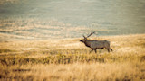
Feature image via Tony Bynum.
Shop
Sign In or Create a Free Account
Related
Elk
Ask MeatEater: How Do You Hunt Elk in the Snow?

Elk
How to Call Elk like Jason Phelps