How to E-Scout for Shed Hunting

Shed hunting, from the outside looking in, can seem quite simple: walk a lot, look on the ground, and find antlers. But the search for whitetail sheds israrely this straightforward.
Consistent shed hunting success requires both an understanding of deer habitat and behavior, and a smart strategy for searching therightplaces. Scouting with online maps, known ase-scouting, can help with both of these tasks.
Why?
One quality separates expert shed hunters from all the rest: efficiency.
As I wrote ina previous MeatEater featureon shed hunting, “shed antlers are not spread randomly across a landscape. Instead, they are most commonly found in concentrated areas for very specific reasons. With this being the case, the most effective shed hunters are the most efficient shed hunters. It’s those who spend the majority of their time focused on searching these key areas.”
Rather than wandering aimlessly and wasting countless hours on low-odds, random locations, the efficient shed hunter spends the majority of their time in the few places that are most likely to hold bone. They speed past low deer activity dead zones and slow down in hot spots. In these most important locations, they apply extra attention and care. They walk slower, check behind obstacles, and look from different angles, maybe even making multiple passes.
An efficient shed hunt begins by having a plan in place for the day’s walk before even leaving home. E-scouting makes this possible.
This process involves a careful study of online aerial and topographic maps to determine exactly which locations will have the highest odds of holding sheds. Those places should be the focus of your time. There are two general types of locations to focus on when e-scouting for antlers: quality late-season food sources and bedding areas.
Food
A buck’s life in winter revolves around food. Find the best food in a given area and you’ll find where bucks are spending their time. Find where bucks are spending their time and you’ll find antlers. So, how can you locate food sources on maps?
Crop fields will be the easiest to identify. These can be located on aerial maps by looking for the typical rectangular or circular shape of an ag field in one solid color. While you won’t be able to determine what’s planted in a field, you can make some assumptions based on regional norms (ie. corn and beans in the Midwest) or find out with a quick phone call to a fish & game or USDA office in the area. Corn, beans, alfalfa, winter wheat, clover, and other cover crops can all potentially attract deer over the winter.
Late-season food can also be found in the timber, the most likely areas being those where significant cutting or burning has occurred. Clear or select cuts are often visible on aerial imagery with a clearly defined edge and different color in contrast to the standing timber nearby. If you zoom in, you can sometimes see downed treetops as well.
Find these types of locations usingonX Huntand mark them with waypoints for further investigation once you arrive on site.
Bedding
The next habitat type to locate while e-scouting is bedding areas nearest to these high-quality winter food sources. Active bedding areas seem to hold more sheds than any other location, most likely because bucks spend more of their time in a bed than in any other place during the winter.
Southern-facing hillsides are a particularly attractive winter bedding area for bucks, because these spots get the most sun over the course of the day, attracting deer looking for extra warmth. Turn on the topo lines or 3D rendering on your aerial map and look for southern exposure. A best-case scenario would be to find a hillside with this orientation and a mix of young trees, bushes, and grasses.
My absolute favorite scenario for sheds is a southern-facing hillside, adjacent to an attractive food source, with tall grass and mixed cedar trees.
Another place to scout are concentrations of evergreen trees. This habitat type provides the best thermal cover available to deer in most areas, providing them the protection from wind and snow that is necessary to make it through brutal winter months. These areas stand out clearly on aerial maps with their telltale dark green coloring year-round.
Non-evergreen brushy cover, thickets, and young forest habitat can also provide winter cover and should be marked as potential bedding, along with CRP fields, switchgrass, and other tall, grassy fields.
Finally, in areas where swamps and marshes are present, look for isolated islands of high ground. These swamp islands are often preferred by bucks for bedding areas and can be easily identified in aerial maps by virtue of the unique trees that grow on these dry pockets of ground. In a large swamp of homogenous cattails, a small patch of larger tree crowns are a clear indication of an island.
Mark these likely bedding areas on your map, prioritizing each based on its proximity to the preferred food sources.
Be Efficient
Once you’ve marked your potential food sources and bedding areas on your maps, it’s time to hit the woods. Remember, e-scouting is not foolproof. What might have looked like a cornfield on your map might turn out to be dirt, but it’s a starting point. If you discover such a mistake when you arrive, simply pivot and move on to the next hotspot. Having a plan in place is better than having none at all.
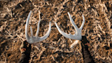
Feature image via Captured Creative.
Shop
Sign In or Create a Free Account
Related
Scout
How Shed Hunting Can Help You Fill Tags

Scout
3 Reasons You Suck at Shed Hunting