The Fur Hat Ice Tour How-To Series is brought to you by ESKIMO.
I grew up going out ice fishing with old guys who probably hadn’t even heard of depth sounders or GPS. But they knew where the good spots were and could return to them every time by triangulating off stuff like a dock, a fence line, and a port-o-potty.
Besides the fact that you don’t need fancy electronics to have an enjoyable and successful time ice fishing, this education taught me that you can learn a lot about what’s under the lake surface from observing what’s above it.
Even with a good flasher or depth sounder it can be daunting to come out to a new lake and figure out where to start. Published underwater maps are sometimes helpful and sometimes wildly inaccurate. So, it’s good to know how to prospect.
So, where do you start? For many, many fish species we pursue through the ice, you’re looking for ridges, shoals, and drop-offs. Each individual species has its individual habitat preferences, but these general rules stand. And, you can get started on locating those features by observing the topography surrounding the lake.
Slopes generally continue at approximately the same angle above and below the water surface. Where a ridgeline tees into the lakeshore, it is likely to keep going underwater. That would be a darn good place to start drilling. A steep hillside or cliff spilling down to the bank will probably be reflected under the ice too. Likewise, where flat land or gentle slopes intersect the lake, you can expect to find shallow water going out a ways.
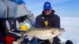
What prospecting means is moving around and drilling a lot of holes until you locate fish or fishy habitat. So, once you’ve noted a landmark on land that you hope is reflected underwater, start drilling and taking soundings. It’s easier to check the depth with a depth sounder or flasher, but you can learn to do it with the jig tied to your line. Find the top of an underwater ridge by drilling in increments perpendicular to the ridge and finding the shallowest spot. Then, you can drill along the ridge to find a prominent drop-off or saddle where the walleyes are hanging out. If you drill one hole at 6 feet, then the next at 30 feet deep, start punching holes between the two to find the lip of the drop-off. These depth transition areas have a higher probability of holding fish than the flat bottom on either side.
These observational skills are mandatory for novice and veteran ice anglers alike. It’s a game of spatial visualization. And the only way to really learn is to do it. So, get out on a frozen lake this year and turn it to Swiss cheese. Chances are you’ll find the honey hole along the way.
Make sure to watch the latest episode of The Fur Hat Ice Tour as Janis Putelis and Pat Durkin take out a homemade airboat in downtown Green Bay, Wisconsin.