Helping Biologists by Invading Animals’ Privacy
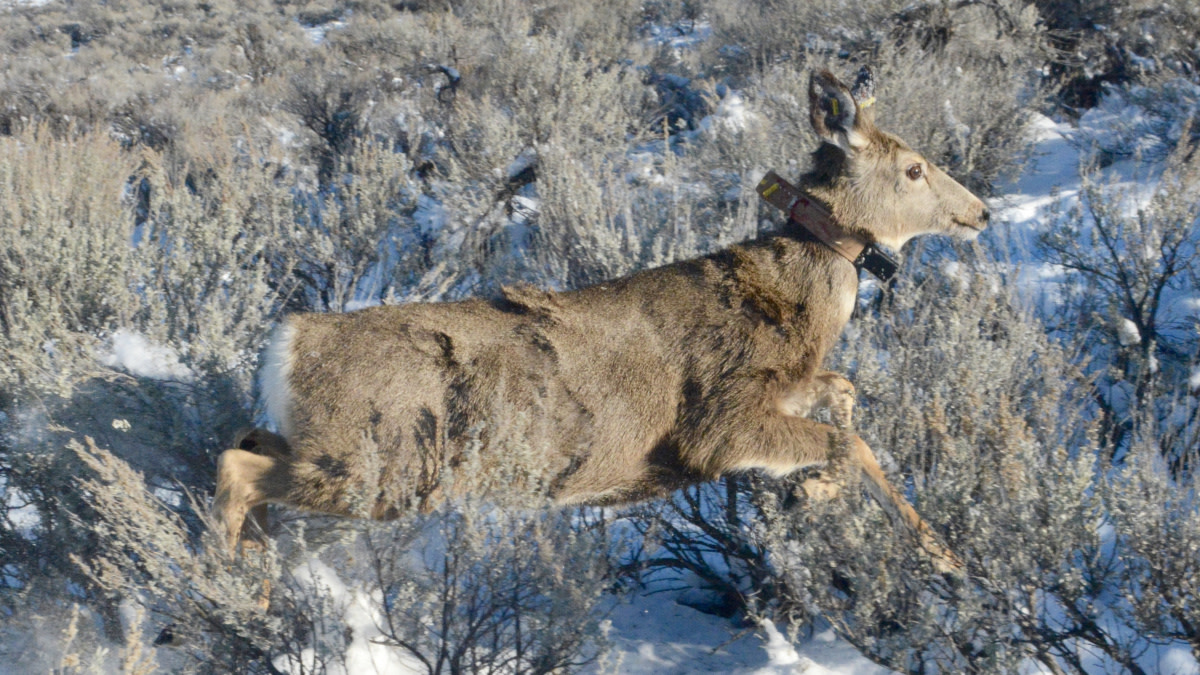

Pinpoint data from ever-shrinking GPS devices are giving biologists increasingly detailed information on when, where, and how wired-up wildlife move about their worlds.
But scientists are just starting to interpret what all of it means. The optimists among them think they’ll one day unravel much of that GPS-driven data and coordinates to explain why birds and mammals make their many mysterious moves. For now, though, they often can only marvel at events transmitted from GPS-toting collars, implants, and harnesses.
Some of the things biologists ponder are: How can a Wyoming muley doe make the same125-mile migrationevery year and perfectly retrace its route? Why would a snowy owl perch on a weather buoy in the Atlantic Ocean 100 miles offshore from New England during winter? Why did aWisconsin wolfmake a 500-mile journey around Wisconsin and Minnesota, just to settle less than 30 miles from where it started?
Riding a Revolution
Well, maybe GPS data can never explain the quirks of individual predators and prey, but until recently, no one could even document such confounding journeys. As the saying goes, we didn’t know what we didn’t know.
“Just a few years ago you didn’t bother asking some wildlife-related questions because you had no way to answer them,” said Duane Diefenbach, a Pennsylvania wildlife research biologist with theU.S. Geological Survey, and leader of the state’s long-term deer study. His team monitors at least 40 deer annually with GPS devices, which are getting smaller, lighter, stronger, and more impervious to wear, tear, and weather.
“GPS coordinates, satellite communications, miniaturized electronics, and tiny, long-lasting batteries are changing everything for us, but we can’t take credit for all that technology,” Diefenbach said. “The market for GPS collars for wildlife is small. It’s not exactly a money-maker. The 5 billion people buying and using smartphones are driving that technology. The wildlife profession is just riding that revolution.”
The innovations don’t start and stop with GPS, either. Prof. Garrett Street, a self-described “movement ecologist” atMississippi State University, said a technology called “accelerometers” are providing yet another layer of data-driven insights into animal activities. Every time you pick up a smartphone or digital camera, and see images quickly right themselves on the screen, you’re glimpsing accelerometers at work.
“We’re basically putting high-end Fitbits on animals,” Street said. “When paired with GPS technology, we’re using accelerometers to count these animals’ steps, their travel distances, and their expended energy. We have the capacity to learn what the animal is doing based on the accelerometer’s signals. We can know which direction they’re facing, and when they’re eating, running, fighting, mating, or wallowing. We’re prying deeper than ever into the intimate lives of animals.”
Document Now, Explain Later
So much data is being recorded, stored, streamed, and downloaded, however, that it could be years, even decades, before it’s analyzed to explore questions not yet conceived. Dan Storm, a research-ecologist with theWisconsin Department of Natural Resources, leads a team that’s been collaring deer, coyotes, and bobcats in southwestern Wisconsin to study predator impacts in a region beset by North America’s worst outbreak ofchronic wasting disease.
Storm and his team have put GPS collars on 550 deer so far, and eventually will have collared and monitored 800 wild whitetails. When monitoring spring dispersals and fall rutting activity, Storm sets the GPS units to record locations hourly. He set the collars to collect that data every six hours during less active periods in summer and winter. But with 550 deer “on the air,” that’s still a minimum of 22,000 GPS coordinates accumulating daily in huge data banks.
“We’ve hardly looked at all the movement data, relatively speaking, because we’re currently focused on survival rates,” Storm said. “But the more deer we monitor, the more questions we’ll start asking. It’s becoming clear that CWD prevalence there is moving and worsening more north and west than south and east. Why is that? As we start analyzing the movements of hundreds of deer, maybe we’ll learn which landscapes hinder or facilitate movements that increase disease transmission. As we develop hypotheses on how topography affects juvenile buck dispersals, we’ll have lots of data to test those ideas.”
Real-World Insights
Not all GPS-based research awaits future analysis, however. TheMissouri Department of Conservationannounced in July that ongoing research justified reducing the state’s CWD management zone from 48 counties to 29, freeing 19 counties from tighter restrictions and mandatory sampling.
When the agency designed the CWD zone in 2012, it included counties within 25 miles of known CWD cases. That 25-mile radius was based on research from other states that documented deer, especially young bucks, dispersing up to 25 miles from their birth sites. Recent research with GPS collars, however, found that over 90% of Missouri bucks dispersed less than 10 miles. After applying a 10-mile radius to known cases, the MDC downsized its CWD zone.
GPS technology also helps biologists identify bucks by personality types, and how they invite or avoid risks. Ashley Jones, one of Street’s graduate researchers at Mississippi State University, used GPS data to identify and monitor 18 bucks she called “movers” and 25 bucks with “sedentary” traits. Jones documented that movers had 81% more risky encounters with hunters than did sedentary bucks during the rut’s peak. She also found that bucks aged 2½ and 3½ took significantly more risks than did bucks 4½ and older during the rut’s peak. However, bucks 5½ and older took more risks post-rut.
Perhaps the most famous example of high-tech monitoring, however, is theWyoming Migration Initiative, which is connecting the dots on coordinates from GPS-collared elk, pronghorns, and mule deer year-round. The book “Wild Migrations: Atlas of Wyoming’s Ungulates,” documents the initiative’s extensive work and insights.
One man who marvels at GPS revelations is William Rudd, a retiredWyoming Game and Fish Departmentbiologist, who in 2012 cofounded the Migration Initiative with University of Wyoming zoology professor Matt Kaufman, director of the operation. Rudd recalls heating and shaping PVC pipe early in his 30-year career to handcraft VHF collars for elk. He said VHF collars from the 1970s and early 1980s were so large and heavy that only elk-size animals could carry them.
Rudd worked with those collars as a graduate student in 1980-81 to study elk east of Yellowstone National Park. His efforts overlapped and expanded on insights into elk migrations in Yellowstone made by brothers John and Frank Craighead during the 1960s with basic color-coded ID collars, and during the 1970s with VHF collars.
Remote Monitoring
GPS collars have become so sophisticated and widespread the past two decades that people now track ungulates online via the Migration Initiative. “This technology lets you collar an animal, walk away, and let the collar do the work for you,” Rudd said. “It’s fascinating for wildlife nerds. The detail of the information is incredible. It lets you see the influence of individual fences, roads, and other obstacles on migration routes, and helps guide our efforts to preserve these corridors.”
Rudd said GPS details also unveil how animals use those migration corridors. All those hundreds of thousands of GPS coordinates show, in human terms, individual animals leaving their driveways, turning onto two-lane roads, connecting to busier streets and boulevards, and eventually merging onto multi-lane highways with scores of other migrating animals.
“Migrations are much less mysterious now,” Rudd said. “The big takeaway is that corridors are more of a way for those species to make a living off the landscape, and not just a means to get somewhere. As mule deer travel, they select routes where they’ll find nutritious vegetation along the way. When they find it, they’ll spend days or weeks at stopovers before continuing on. About 80% of their migration time is spent at stopovers between their winter and summer range.”
Rudd said the technology often fills in details of what biologists like the Craigheads—and native Americans, trappers and explorers centuries before —observed long before. But all those observations and information were hard won, and left many questions hanging.
Scott Walter, the Wisconsin DNR’s large-carnivore ecologist, said the agency began collaring and tracking gray wolves in 1980 using VHF collars. Those transmitters required huge investments of time, manpower and machinery as staff drove, flew, and snowshoed vast forests with big antennas to detect and triangulate signals to determine each location. And if the animal dispersed to parts unknown, biologists never knew if the animal was living elsewhere or if the VHF transmitter quit working.
Walter said the Wisconsin DNR typically tracks 60 to 70 wolves each year with GPS collars, which are more reliable, durable and accurate than VHF units. GPS technology also provides better data for estimating pack sizes, pack numbers, territory sizes, and survival rates.
“GPS collars cost more, but they save time and money because we can now track the wolves from a desktop computer in real-time,” Walter said. “The information is invaluable. It provides a cool window into wolves as individuals and as a species.”
Online Data Warehouse
Professor Bronson Strickland at Mississippi State University expects GPS data to keep solving mysteries as universities and agencies collaborate through projects likeMovebank, a free online system for researchers to manage, share, analyze, and archive animal movement data.
“All GPS data now being collected on wildlife will answer many of tomorrow’s big questions,” Strickland said. “Movebank has data on birds, fish, animals that literally lets you track nearly everything, no matter where it lives. It’s fun to think of the possibilities. We could already have millions of data points for comparing the movements and habitat choices of CWD-positive and negative deer. Or we could use GPS data to study how deer use different habitats to mitigate heat or cold extremes, or just predict where bucks on specific properties will most likely spar, rest, and forage.”
Dr. Grant Woods, owner/creator of “Growing Deer-TV” and The Proving Grounds in southwestern Missouri, sees another advantage of GPS-driven insights: It has credibility with hunters. Hunters and anglers have used GPS devices for much of the past three decades, and speak its language.
“We’re seeing more real-world use of GPS data to answer questions and change policies that affect lots of hunters,” Woods said. “When you can explain your plan on a screen with technology people understand, they find it believable and acceptable.”
Feature image via Idaho Fish and Game.
Shop
Sign In or Create a Free Account
Related
Wildlife Management
Helping Biologists by Invading Animals’ Privacy
Manage
You Won’t Believe How Far this Buck Traveled


